A few years ago when I had really caught the running bug, a friend suggested I try the Brighton Trailblazer, a 10km trail run near Woodingdean in Brighton. I vividly remember the outgoing 2 or 3 miles with the fantastic views looking out towards Lewes. It starts with a gentle downhill with time to look around and take in the stunning landscape. That’s the bit I remember most and then, of course, the harsh uphill known as Snake climb to the finish. What I didn’t realise was that the mid section ran through a secluded valley that was once home to a hamlet called Balsdean.
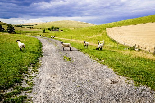
Balsdean near Brighton: Photo by Bill Hunt
Fortunately, my renewed interest in running on the South Downs took me back to the same area. I love studying a map and picking out new routes so I set off from Preston Park towards Rottingdean via Hollingbury golf course, Moulsecoomb, Bevendean and Woodingdean. I ended up running down Snake climb, the opposite way I’d done before. Being a descent, rather than a gruelling uphill, you get to see so much more. The trail runs along the side of a valley and down into the heart of Balsdean. There’s a small visible clue to the hamlet in the form of a derelict farm building – you can just make it out in the image above – but everything else was demolished after the hamlet had been used for target practice by the army during WW2. This blog by David Cuthbertson, is particularly informative about Balsdean before and during the war.
From Balsdean, a track leads to Rottingdean, past a water pumping station. To get a better feel for the area, take a look at this collection of photos by BrightonDJ on Flickr that really captures the isolation and beauty of the valley.
As I searched for more information about this intriguing area, I came across a map on Ernest blog. I recognised the map of Balsdean immediately but the accompanying article features the Brighton based band Grasscut who released 1 inch/1/2 mile in 2012, a collection of tracks inspired by a walk around the Balsdean area. I clicked on the map which links to Curlews.


